Technology
Created from a belief in the power of collaboration, the art of understanding & the act of cross-disciplinary work
Urban Analytics & Visualisation
New Tashkent, Tashkent, Uzbekistan
Procedural City Generation
The overall visioning, design and multi-disciplinary coordination of a masterplan for a new ‘twin city’ located immediately to the east of the existing capital of Uzbekistan. The proposal has an estimated population of 2 million people on a site of 20,000 hectares; making it one of the largest new city projects in the world.
Cross Works developed the masterplan from initial visioning, to CMP, to DMP, and now onto the development of urban design, landscape and architectural guidelines for the city.


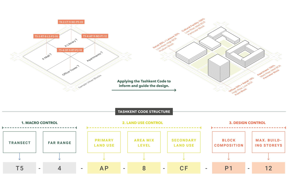
X-code / Tashkent Code
Algorithm Design & Implementation
The Tashkent Code, also known as X Code, is an advanced urban coding framework that expands upon traditional transect urbanism principles pioneered by Duany and Falk. Designed specifically for the New Tashkent project but adaptable to any context, the code introduces a granular three-group classification system: macro control (e.g., transect and FAR range), land use control (e.g., primary use, mix, secondary use), and design control (e.g., block composition, max height). This structure enables detailed procedural generation of city blocks and reverse attribution from manually designed plans.
The X Code system was implemented in CityEngine and Grasshopper, allowing for automatic city generation, GIS-ready attributes, and seamless integration into cadastral systems. Its adaptability makes it a critical tool in managing urban complexity across diverse geographies and cultures.
New Tashkent Architectural Guidelines & Pilot Projects
Procedural Facade Generation
The New Tashkent Procedural Façade Generator is a computational design framework that produces context-driven facades while aligning with architectural guidelines. Rather than a simple automation tool, it functions as a structured kit of parts, allowing controlled procedural design.
Starting from a masterplan massing, it enables a step-by-step process: breaking the massing, assigning vertical and horizontal subdivisions, defining openings, and adding balconies or terraces. It differentiates between street interface, main body, and rooftop, ensuring context-sensitive articulation. Orientation-driven logic adapts designs to environmental factors, creating structured yet flexible facades ready for refinement.


Hilltop Masterplan, KSA
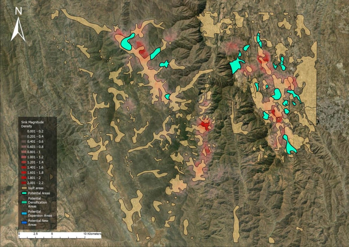
Geospatial Analysis / Gap Analysis
This geospatial analysis focused on a mountainous region in the country’s highest peaks. The study assessed the suitability of areas for development and expansion, supporting six masterplans currently in progress. Key evaluations included topography, slope, built areas, rainfall, road networks, connectivity, water bodies, flood susceptibility, and visibility to the Red Sea.
The results identified potential areas for densification, masterplan expansion, and new developments based on critical factors such as slope, flood risk, and infrastructure connectivity. The analysis built upon previous studies, incorporating updated spatial datasets and advanced GIS methodologies to ensure a sustainable and strategic approach to urban growth in this complex terrain.
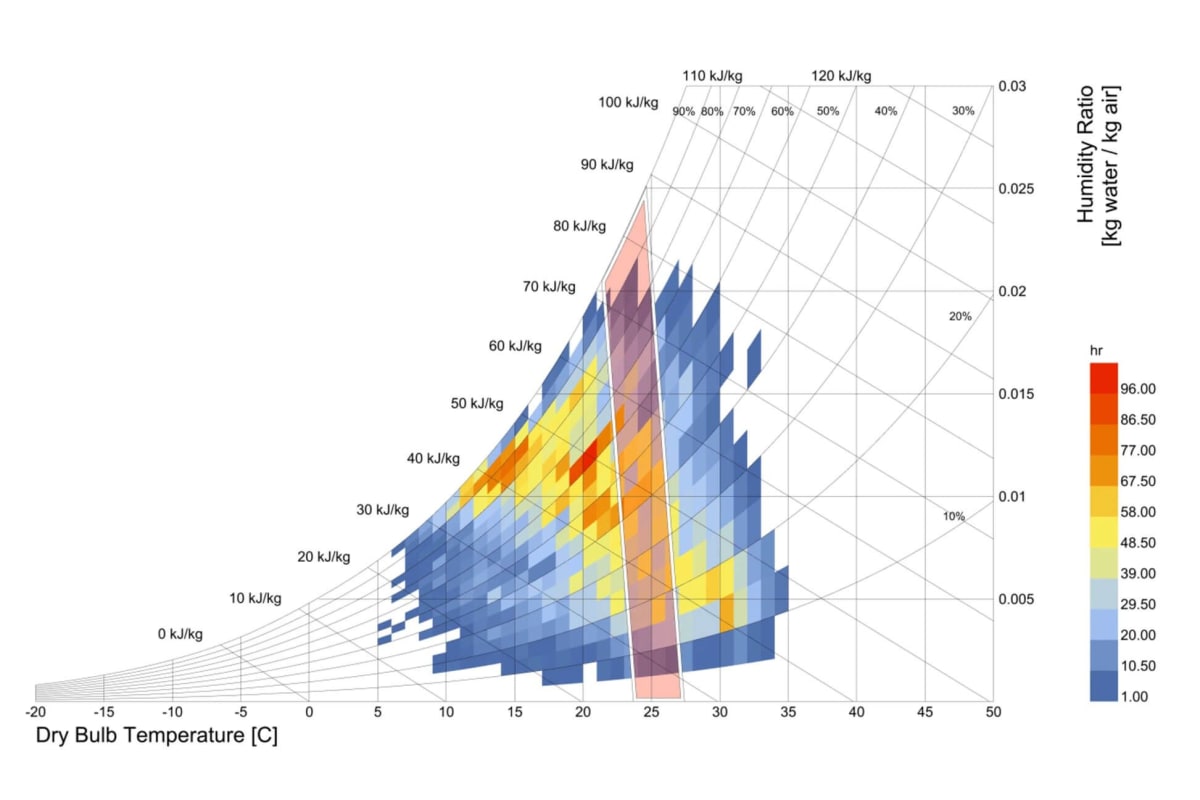
Hilltop Masterplan, KSA
Computational Climate Analysis
Climate Analysis examines unique environmental conditions in any particular region; using open source weather data, which provides critical insights that inform the development of a masterplans. Key analyses includes dry bulb temperature, relative humidity, wind speed, cloud cover, wind rose patterns, psychrometric comfort zones, and a bioclimatic chart.
The findings highlighted environmental opportunities and constraints, guiding sustainable planning and design strategies. By integrating climate data with the broader geospatial framework, the analysis supported the development of resilient and adaptive masterplans suited to the region’s distinctive topography and climatic conditions.
New Tashkent Immersive Experience
Unreal Engine Online Interactive Environments
The New Tashkent D1 DMP features a cutting-edge Unreal Engine immersive experience, offering an interactive way to explore the future city. Three distinct environments—available for desktop and VR—are accessible via online pixel streaming or standalone downloads, ensuring broad accessibility without high-end hardware requirements.
Beyond traditional 3D visualisation, this immersive experience allows users to navigate through proposed districts, infrastructure, and landscapes in real time. Integrated with the New Tashkent Digital Twin, it provides live geospatial data, enabling both stakeholders and the public to engage with the masterplan dynamically. By merging high-fidelity visualisation with real-world planning data, the twin transforms urban development into an interactive and accessible digital experience.

OFF-GRID
GPS-enabled Offline Masterplan Visualisation With AR
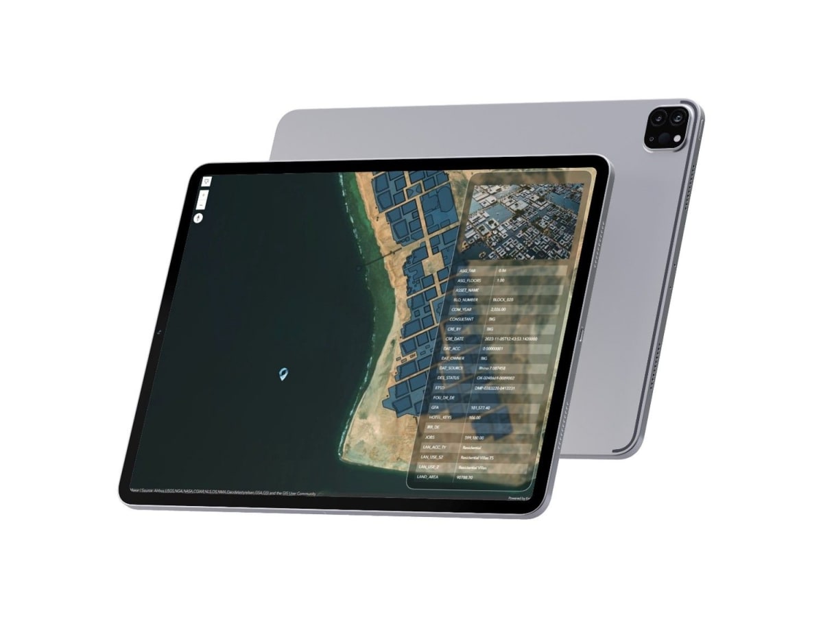
OFF-GRID is an iOS application designed for professionals working in remote or signal-deprived areas, enabling seamless exploration of geospatial data offline. It supports offline maps using .mmpk files, real-time GPS tracking, and detailed attribute access for points of interest.
The app features augmented reality (AR) capabilities, allowing users to visualise masterplans or 3D models in Tabletop AR mode or geolocated in real-world environments via World AR mode. Designed for intuitive offline navigation and immersive data interaction, OFF-GRID is a powerful tool for fieldwork, urban planning, and large-scale project visualisation. Now available on the App Store, it bridges the gap between geospatial data and real-world applications.

Software Engineering & Applications
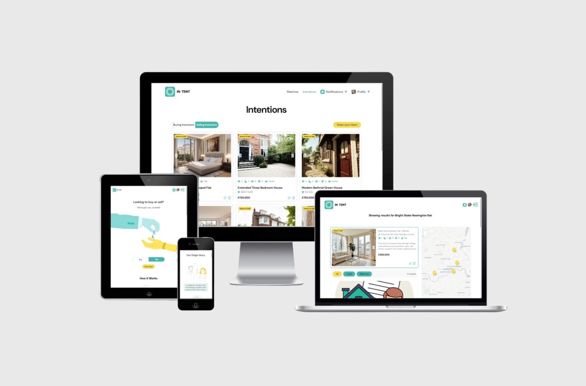
IN-TENT
Matchmaking Real Estate Market App
IN-TENT is a web application designed to create a more balanced marketplace by enabling both buyers and sellers to post their "intents"—geolocated listings of what they are looking to buy or sell. This approach allows users to explore localized demand and supply through an interactive map, fostering more relevant and direct connections.
The app currently supports real estate, vehicles, and musical instruments, demonstrating its flexibility across multiple product types. A fully functional proof-of-concept has been completed, and the project is now entering its second funding phase with placeholder intents to showcase how the system operates. The platform is built for scalability, ensuring seamless geolocation-based intent visualization and efficient handling of diverse listings.


UP-DATE
Change Management App
Developed originally for a major Middle Eastern client, this change management software streamlines bureaucratic processes in masterplanning and AEC projects, optimising workflows for approvals, modifications, and project oversight. Initially tailored for a large-scale development, the system was later adapted for broader use in complex urban planning initiatives.
The app integrates with ArcGIS, enabling live geospatial data handling and providing advanced GIS tools for land-use changes, boundary adjustments, and infrastructure updates. With multi-platform accessibility and project management integration—including budgeting and timeline tracking—it enhances decisionmaking efficiency across all project phases, ensuring smoother coordination between stakeholders.


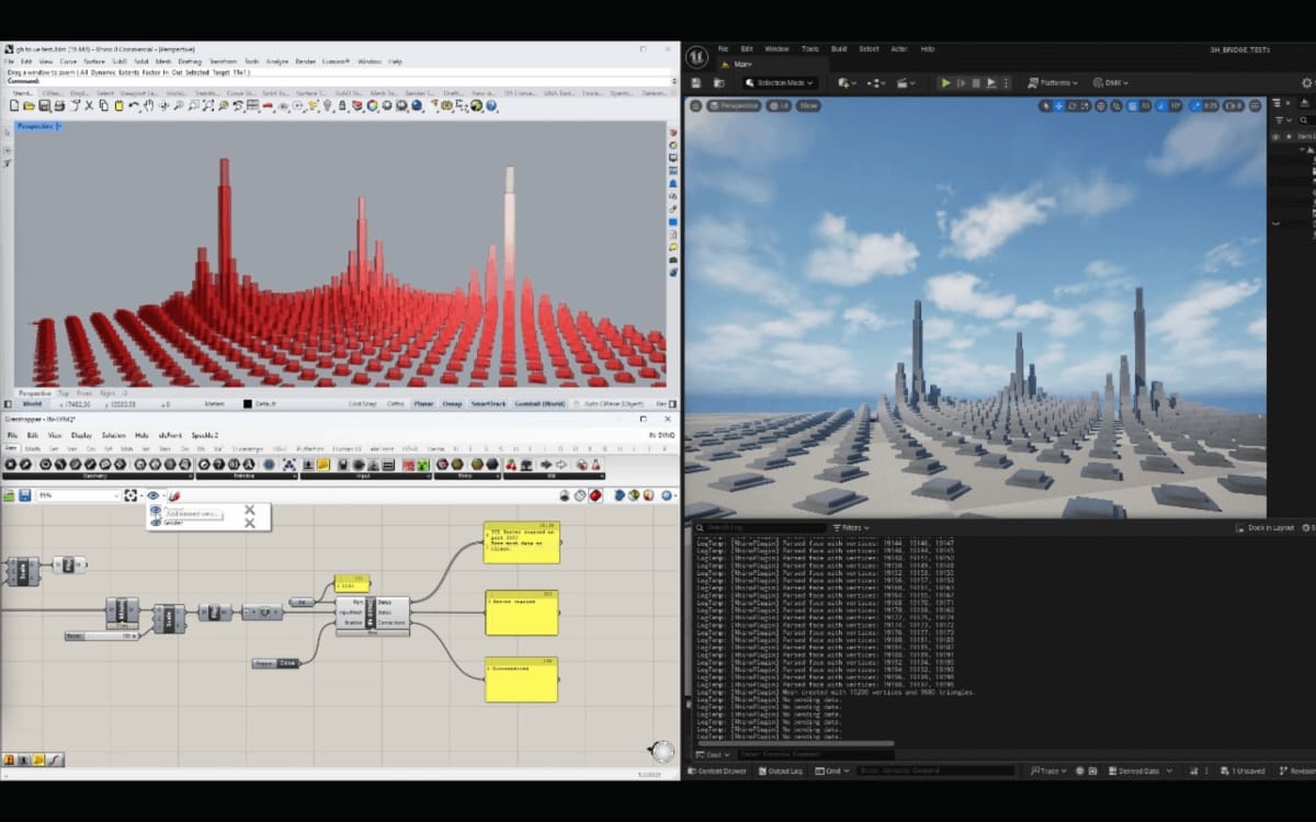
IN-SYNQ
Rhino/grasshopper - Unreal Engine Live Bridge
In-Synq is an open-source project designed to connect Rhino/Grasshopper with Unreal Engine, enabling real-time synchronization of parametric designs. This approach removes the need for repetitive baking or exporting, streamlining workflows for architects, designers, and engineers. As a community-driven initiative, it aims to make advanced tools and workflows more accessible.
The project includes WebSocket and cache file-based communication for seamless interoperability, supporting live multi-user collaboration, various geometry types, and procedural updates in Unreal Engine. An application for the Epic MegaGrant has been submitted to further its development.
Digital Twin & Web Design
New Tashkent Digital Twin
Digital Twins
The New Tashkent Digital Twin is a state-of-the-art geospatial and interactive visualization platform, built to showcase the planning, design, and future vision of the new city. Unlike traditional twins, it integrates all stages of the masterplan, from initial concepts to detailed proposals, as well as infrastructure, landscape, and urban design guidelines. Custom raster basemaps, proposed topographies, 3D renders, and immersive videos provide a comprehensive, multi-layered experience.
The twin features three Unreal Engine-based immersive environments (desktop and VR) accessible via online pixel streaming or standalone downloads—a major achievement in accessibility. Fully integrated with the city’s GIS portal, it allows for public access to non-sensitive layers, empowering citizens to engage with the city’s development.


New Kharkhorum Digital Twin
Digital Twin
The New Kharkhorum Digital Twin is an advanced geospatial platform designed to visualise the city's masterplan in both 2D and 3D, integrating real-time data and interactive features. Built within a custom GIS portal, it enables seamless exploration of the proposed urban framework, infrastructure, and modular design principles.
A key innovation is its seasonal analysis capability, which illustrates how nomadic settlements adapt throughout the year. The system's attributed geometry dynamically adjusts to reflect these transitions, offering valuable insights into the relationship between urban growth and Mongolia’s unique cultural and environmental conditions. By merging geospatial intelligence with interactive visualisation, the twin serves as a powerful tool for planners, stakeholders, and the public to engage with the future of New Kharkhorum.


IMMOROSE
Web Development
IMMO ROSE, a leading real estate developer in Kinshasa, Congo, underwent a full rebranding and digital transformation to align with its luxury-focused image. A new website was developed with a minimalist, high-end aesthetic, featuring dynamic, interactive elements to showcase the brand and its developments.
Built on a LAMP stack with a streamlined WordPress foundation, the site includes a custom admin panel, allowing seamless content updates. Tailored input fields enable the addition of descriptions, images, videos, and technical sheets, dynamically generating project pages that adhere to the designer’s vision. Initially designed for client management, the platform continues to receive ongoing updates and maintenance to ensure a polished digital presence.


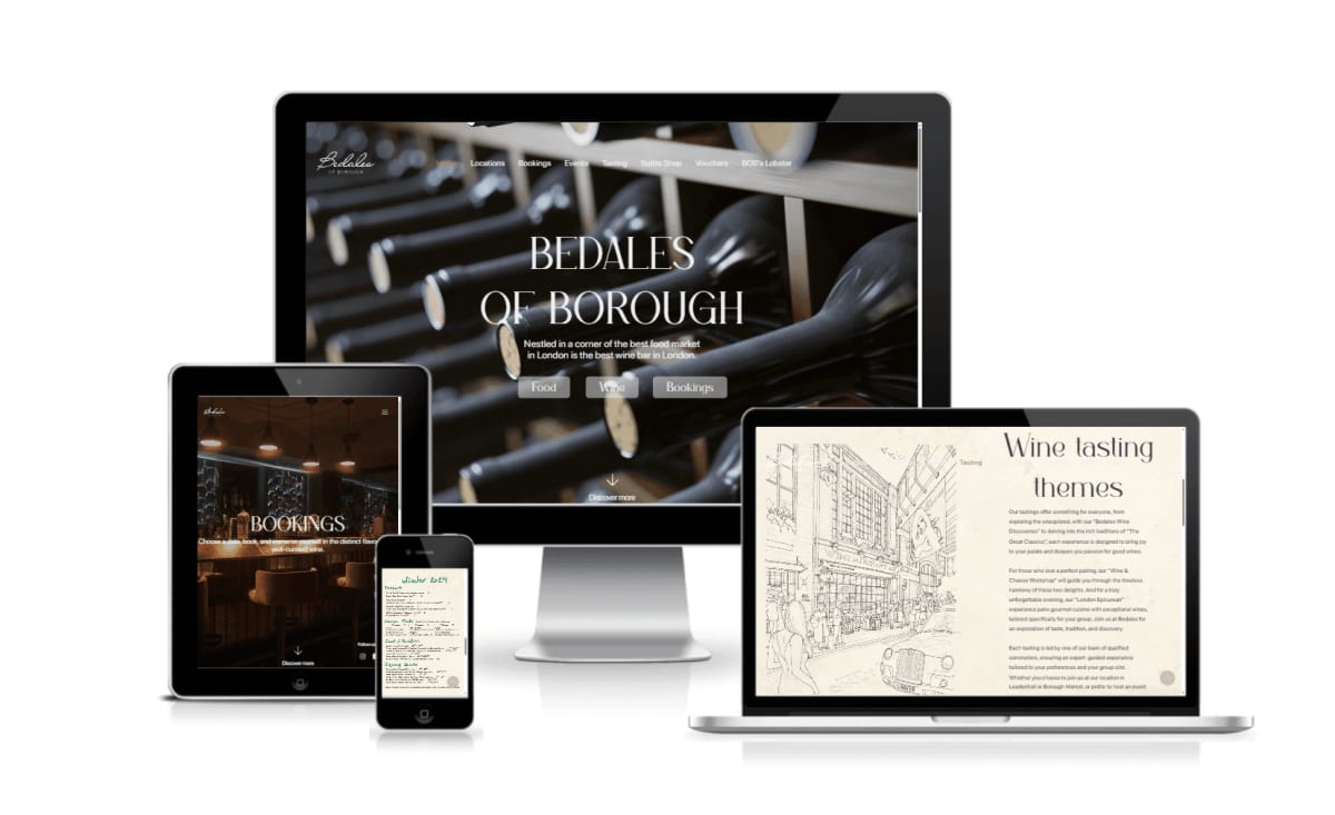
Bedales of Borough
Web Development
Bedales of Borough, a popular wine bar in London’s Borough Market, sought a centralised website to unify its various businesses, including another bar in Leadenhall Market, a food truck, an online wine shop, and wine experiences. The new site provides a cohesive online presence while maintaining the distinct identity of each segment.
Developed on a LAMP stack with WordPress, the website features a custom admin panel for managing weekly wine menus and experiences, replacing outdated PDFs and significantly improving SEO/SEM performance. The result is a clean, inviting design that blends functionality with the brand’s stylish and approachable character. While security updates and maintenance are ongoing, content updates are now managed in-house.

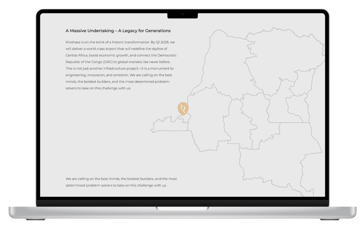
Infrarose / Aéroport International De N’djili
Digital Partner
INFRAROSE specialises in infrastructure development and has taken a leading role in the expansion of Aéroport International de N’Djili in Kinshasa, the largest airport in Central Africa. As the digital partner for both the company and the airport expansion project, we are delivering a comprehensive suite of digital solutions to support their growth and communication strategy.
Our work includes the development of the INFRAROSE corporate website and a dedicated digital platform for the airport expansion, ensuring clear and dynamic project communication. We are also implementing digital signatures, virtual business cards, and secure digital communications. Additionally, we are producing interactive digital cartography to visualise and manage the evolving infrastructure with geospatial data.

Services

Software Engineering
We design and build software systems—from web apps and APIs to internal tools—focusing on clean code, clear architecture, and long-term maintainability for teams at any stage.

Visual Branding
We design and build software systems—from web apps and APIs to internal tools—focusing on clean code, clear architecture, and long-term maintainability for teams at any stage.

Web Design
We design websites that are clear, functional, and easy to use. From structure to visuals, we focus on user needs and responsive layouts that work across devices.

Graphic Design
We create graphic design that communicates clearly and works across print and digital. From layouts to visuals, we focus on purpose, consistency, and strong visual impact.